En
Log in
All resources
Create a design
Tools
7,118 Free Images of Engraved Maps
maps from the earth and its inhabitants, vol. iv
copper engraving print
british library
joan blaeu
atlas maior, vol 3 (germany) - joan blaeu, 1667 - bl 114.h(star).3
maps from the earth and its inhabitants, vol. xviii
maps from the earth and its inhabitants, vol. xii
maps from the earth and its inhabitants, vol. iii
maps from the earth and its inhabitants, vol. viii
maps from the earth and its inhabitants, vol. v
maps from the earth and its inhabitants, vol. ix
maps of the hindu kush
maps from the earth and its inhabitants, vol. x
topographic maps of africa
maps from the earth and its inhabitants, vol. xvi
topographic maps of mexico
maps from the earth and its inhabitants, vol. viii
old maps of kashmir
maps from the earth and its inhabitants, vol. xvi
19th-century maps of mexico city
old maps of reaches or the estuary of the river thames
maps from the earth and its inhabitants, vol. iv
maps from the earth and its inhabitants, vol. xi
old maps of tripoli
maps from the earth and its inhabitants, vol. xviii
population density maps of south america
maps from the earth and its inhabitants, vol. v
old maps of the black sea
maps from the earth and its inhabitants, vol. xvi
19th-century maps of guadeloupe
maps from the earth and its inhabitants, vol. xii
maps of the congo river
maps from the earth and its inhabitants, vol. iv
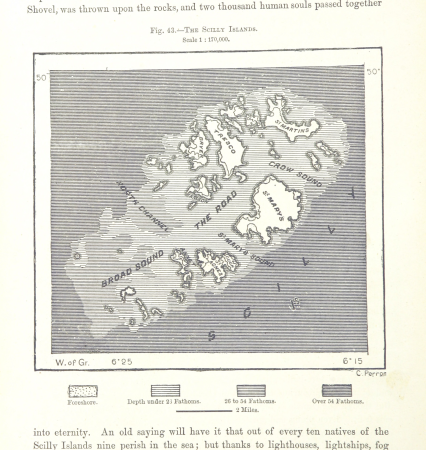
maps of the scilly islands
maps from the earth and its inhabitants, vol. vi
bathymetric maps of the caspian sea
maps from the earth and its inhabitants, vol. ix
old maps of medina
maps from the earth and its inhabitants, vol. v
population density maps of europe
maps from the earth and its inhabitants, vol. iv
19th-century maps of gloucestershire
maps from the earth and its inhabitants, vol. iii
old maps of rijeka
maps from the earth and its inhabitants, vol. iv
old maps of lindisfarne
maps from the earth and its inhabitants, vol. iv
maps of the british isles
maps from the earth and its inhabitants, vol. xv
19th-century maps of quebec
maps from the earth and its inhabitants, vol. iv
old maps of hartlepool
maps from the earth and its inhabitants, vol. iv
19th-century maps of warwickshire
maps from the earth and its inhabitants, vol. iv
19th-century maps of kent
maps from the earth and its inhabitants, vol. ix
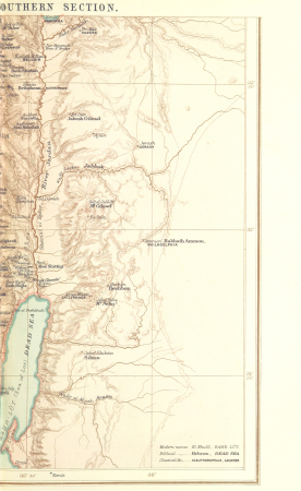
1870s maps of palestine
maps from the earth and its inhabitants, vol. xiv
maps of easter island
maps from the earth and its inhabitants, vol. xvii
19th-century maps of san francisco
maps from the earth and its inhabitants, vol. vii
old maps of tokyo
maps from the earth and its inhabitants, vol. iii
old maps of trieste
maps from the earth and its inhabitants, vol. iv
maps of the british isles
maps from the earth and its inhabitants, vol. xvi
maps of agriculture in mexico
maps from the earth and its inhabitants, vol. iv
19th-century maps of the isle of man
maps from the earth and its inhabitants, vol. xvii
maps of native american tribal territories
maps from the earth and its inhabitants, vol. vii
old maps of xi'an
maps from the earth and its inhabitants, vol. iv
19th-century maps of the isle of wight
maps from the earth and its inhabitants, vol. iv
old maps of the orkney islands
maps from the earth and its inhabitants, vol. iv
old maps of shrewsbury
maps from the earth and its inhabitants, vol. xvii
1870s maps of the united states
maps from the earth and its inhabitants, vol. v
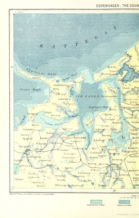
19th-century maps of copenhagen
maps from the earth and its inhabitants, vol. xiii
maps of the kingdom of kongo
maps from the earth and its inhabitants, vol. xii
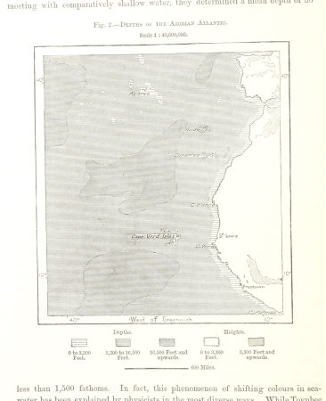
bathymetric maps of the atlantic ocean
maps from the earth and its inhabitants, vol. vii
maps of the yellow river
maps from the earth and its inhabitants, vol. xviii
topographic maps of colombia
maps from the earth and its inhabitants, vol. vii
maps of weather and climate of china
maps from the earth and its inhabitants, vol. iii
old maps of pula
maps from the earth and its inhabitants, vol. xiv
1870s maps of hawaii
maps from the earth and its inhabitants, vol. iii
old maps of the rhine
maps from the earth and its inhabitants, vol. v
19th-century maps of copenhagen
maps from the earth and its inhabitants, vol. iv
1870s maps of the british isles
maps from the earth and its inhabitants, vol. v
19th-century maps of crimea
maps from the earth and its inhabitants, vol. xviii
19th-century maps of trinidad and tobago
maps from the earth and its inhabitants, vol. viii
religion maps of india
maps from the earth and its inhabitants, vol. x
old maps of africa
maps from the earth and its inhabitants, vol. xvii
maps of the history of the united states
maps from the earth and its inhabitants, vol. iii
old maps of hamburg
maps from the earth and its inhabitants, vol. xii
maps of the congo river
maps from the earth and its inhabitants, vol. xii
maps of trade winds
maps from the earth and its inhabitants, vol. viii
old maps of kolkata
maps from the earth and its inhabitants, vol. ix
maps of afro-eurasia
maps from the earth and its inhabitants, vol. vi
atmospheric pressure maps
engravings of topographia braunschweig lüneburg
baroque
maps of asia by mercator-hondius
squier and davis images
hopeton earthworks
atlas maior, vol 3 (germany) - joan blaeu, 1667 - bl 114.h(star).3
copper engraving print
atlas maior, vol 3 (germany) - joan blaeu, 1667 - bl 114.h(star).3
copper engraving print
atlas maior, vol 3 (germany) - joan blaeu, 1667 - bl 114.h(star).3
copper engraving print
atlas maior, vol 3 (germany) - joan blaeu, 1667 - bl 114.h(star).3
copper engraving print
atlas maior, vol 3 (germany) - joan blaeu, 1667 - bl 114.h(star).3
copper engraving print
atlas maior, vol 3 (germany) - joan blaeu, 1667 - bl 114.h(star).3
copper engraving print
atlas maior, vol 3 (germany) - joan blaeu, 1667 - bl 114.h(star).3
copper engraving print
atlas maior, vol 4 (netherlands) - joan blaeu, 1667 - bl 114.h(star).4
copper engraving print
atlas maior, vol 4 (netherlands) - joan blaeu, 1667 - bl 114.h(star).4
copper engraving print
parts of old maps of bremen
baroque
maps from university of amsterdam special collections
atlas der neederlanden
maps from university of amsterdam special collections
atlas der neederlanden
maps from the earth and its inhabitants, vol. xiv
old maps of mauritius
maps from the earth and its inhabitants, vol. vii
old maps of beijing
maps from the earth and its inhabitants, vol. iii
19th-century maps of dresden
maps from the earth and its inhabitants, vol. xiv
old maps of manila
maps from the earth and its inhabitants, vol. xiii
old maps of zanzibar
maps from the earth and its inhabitants, vol. viii
old maps of kashmir
maps from the earth and its inhabitants, vol. iv
19th-century maps of yorkshire
maps from the earth and its inhabitants, vol. x
1870s maps of ethiopia
maps from the earth and its inhabitants, vol. iv
old maps of portsmouth
maps from the earth and its inhabitants, vol. xiii
old maps of luanda
maps from the earth and its inhabitants, vol. viii
maps of alexander the great's wars
maps from the earth and its inhabitants, vol. xviii
topographic maps of south america
maps from the earth and its inhabitants, vol. iv
maps of loch lomond
maps from the earth and its inhabitants, vol. iv
1870s maps of scotland
maps from the earth and its inhabitants, vol. xvii
old maps of the mississippi delta
maps from the earth and its inhabitants, vol. xviii
maps of the indigenous peoples of south america
maps from the earth and its inhabitants, vol. iv
old maps of plymouth and devonport
maps from the earth and its inhabitants, vol. iv
old maps of manchester and salford
maps from the earth and its inhabitants, vol. vi
ethnographic maps of asia
maps from the earth and its inhabitants, vol. xviii
old maps of caracas
maps from the earth and its inhabitants, vol. iv
maps of the british isles
maps from the earth and its inhabitants, vol. xii
old maps of bioko
maps from the earth and its inhabitants, vol. iv
19th-century maps of oxfordshire
maps from the earth and its inhabitants, vol. xii
old maps of the canary islands
maps from the earth and its inhabitants, vol. xiv
population density maps of australia
maps from the earth and its inhabitants, vol. iv
19th-century maps of warwickshire
2301 - 2400 of 7,118
Next page
/ 72